


départ gâchère direction marais

dudu85
User
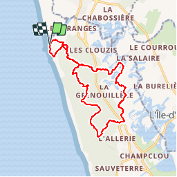

Length
16 km

Max alt
23 m

Uphill gradient
104 m
Km-Effort
17.4 km

Min alt
-1 m

Downhill gradient
105 m
Boucle
Yes
Creation date :
2018-04-17 20:52:25.656
Updated on :
2018-04-17 20:52:25.656
3h16
Difficulty : Very easy

FREE GPS app for hiking
 SityTrail
IGN / Geographical institutes
SityTrail Plus
The world is yours!
About
Trail Other activity of 16 km to be discovered at Pays de la Loire, Vendée, Les Sables-d'Olonne. This trail is proposed by dudu85.
Photos


Positioning
Country:
France
Region :
Pays de la Loire
Department/Province :
Vendée
Municipality :
Les Sables-d'Olonne
Location:
Olonne-sur-Mer
Start:(Dec)
Start:(UTM)
588402 ; 5159744 (30T) N.
Comments